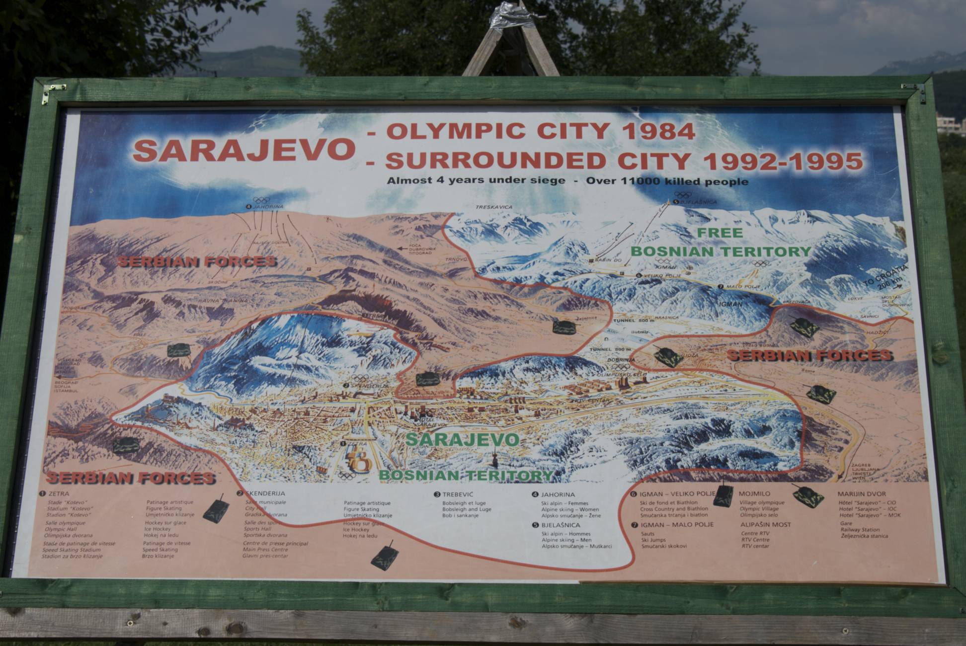
This map details Sarajevo during the siege, with the attackers' territory marked in red, and Sarajevo marked in white. It also marks where the attackers' tanks were. This helps understand that they were completely surrounded, and the only path out could be shot at by the tanks. It does not however, show how much the city was OBLITERATED. But then again, I can't think of any maps that do.
At the top of the map it says in 1984 it was an Olympic city. (the Olympics were held there)And that just makes the siege so much worse. When the Olympics happen in your country,whatever city they're in, the country makes sure it looks really nice. (They want their country to look good when the whole world can see them.)Now at the bottom of the map there are a bunch of numbers followed by lists, if you look for the number on the map, all the things in the numbers list will be there. Like in number 1, there is the Kosevo stadium, the Olympic hall, speed skating stadium and figure skating. In other lists there are: hotels, the city hall, sports hall, press centre, railway stations and more. This really shows how full of life the city was beforehand. So when you read the book, and see how much life sucks in there during the siege, and then you see this, and how much better life was before, it really makes it seem a lot worse.
(sorry if I seem pessimistic)
I like how the picture shows two different dates of the same city, as well as your explanation. I thought your explanation was good and I liked how you talked as if it was your country that had been an olympic city and then less than a decade later completely destroyed.
ReplyDeleteI have a few things to suggest for it to be better thought:
1. MAKE THE IMAGE SMALLER! It literally goes off the screen.
2. In the first sentence of the second paragraph you said
"At the top of the map it says in 1984 it was an Olympic city. [omitted for sake of space] When the Olympics happen in your country,whatever city they're in, the country makes sure it looks really nice."
But the Olympics were already over...
But overall I really enjoyed this post :D
Just saw that it said "sorry couldn't shrink it"
ReplyDeleteI'll find something...
(If you want)
ReplyDeleteThis makes the image is about 2x smaller than the image above: (img src="http://saramistbixian.files.wordpress.com/2008/06/map-of-sarajevo-during-siege.jpg" alt="Map of Sarajevo" width=415 height=278>< >
ignore the bad grammar in the first line please :3
ReplyDeletealso as this didn't get posted (I dislike blogger now) you have to change "(img src=" to "<img src=" with triangular brackets also in between the brackets at the end (where the space is) you need to put /img
Sev, don't comment so much. thnx for your constructive criticism.
ReplyDeleteDid you use the suggestions to shrink the map. If shrinking was not possible why did you not look further to find another map that would also be appropriate.
ReplyDeleteMrs.B